The old railroad corridor passed by eight thriving mining towns. The largest of these towns was Wehrum which once consisted of 230 houses, a bank, hotel, store, post office, school, and two churches. All of the towns were abandoned in the early 1900's and very few remnants of the towns now remain. The trail derives its name from these "ghost towns".
Despite the name, there is nothing spooky about this trail. It is a well-maintained, beautiful trail that winds through the woods, past farms and small towns, and along a river. You are always sure to see other people biking or walking on the trail.


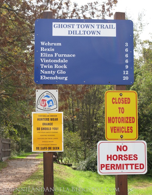
My favorite spot to park and bike from is the Dilltown Access Area. Here there is a large parking lot and a covered picnic area with tables, garbage cans, and restrooms. Also located here is the Dillweed Trailside Shop and Cafe which is a great place get a cold drink or a snack after a long ride. From Dilltown, it is 20 miles on the trail to Ebensburg in one direction and 13 miles to Black Lick in the other.
For an enjoyable biking, running, or walking experience, I recommend the six mile stretch between Dilltown and Vintondale. It is a beautiful, shaded trail mostly along the river and it is very flat, raising only 10 feet in elevation. If you continue on from Vintondale to Nanty Glo, the trail becomes considerably more strenuous, raising 360 feet in elevation.
Here are the access areas of the Ghost Town Trail and their elevations (in feet):
- Black Lick 980'
- Heshbon 1260'
- Dilltown 1350'
- Wehrum 1355'
- Vintondale 1360'
- Twin Rocks 1660'
- Nanty Glo 1720'
- Ebensburg 2000'
www.indianacountyparks.org is an informational website about the parks and trails in Indiana County. It provides locations of and directions to the Ghost Town Trail access points, as well as a brief history and downloadable trail maps.


The trail used to be marked by carved wooden mile posts; a few of which still remain. New, updated posts now mark the trail at each mile.

There are some resting areas with picnic tables and/or benches along the trail.

Remnants of the railroad can seen along the trail.


The trail goes over an old train bridge near Vintondale, PA.

This area's coal mining past is evident along the trail with the sights of boney piles. Boney piles (aka soil tips or slag heaps) are the leftover waste materials produced from coal mining. The large piles are primarily composed of shale. The piles create acid rock drainage; a pollution that creates the "orange rivers" that are common in the area.

The Eliza Furnace is along the Ghost Town Trail in the town of Vintondale. It is "one of Pennsylvania's best preserved iron furnaces. The furnace operated from 1846 to 1849 and is a unique relic of the area's early industrial era." This furnace is one of the few in the country that still has the original heat exchanger piping on the top.

The Mine No. 6 Portal is also located in Vintondale, just over a half mile along the Ghost Town Trail from the Eliza Furnace. "This Miners' Memorial is an opportunity to acknowledge and reflect on the hard lives of those who worked underground. The reconstructed six-by-twelve-foot mine portal entrance stands exactly where the once-bustling Mine No. 6 Portal entrance was located. The life-sized image of men in the middle of a shift-change is etched in black polished stone."


*******
"Converting an abandoned rail corridor into a trail
is not always an easy task, but it is one whose rewards to
the community and region will continue far into the future."
~Peter Harnick
No comments:
Post a Comment